Written by Alex Sivitskis, Teton Science Schools Education Research Faculty and Professional Learning Coach
We’re excited to share a new publication that highlights how place-based learning and geospatial technology are coming together for students in Bhutan. The article, “Using Google Earth Engine to Teach Burn Severity Mapping of Wildfires Across Bhutan,” was recently published and co-authored by Tashi Dema, a geography Teacher at Shari Secondary School in Paro, Bhutan, and Alex Sivitskis, Education Research Faculty and Professional Learning coach for Teton Science Schools.
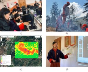
Student progression through the lesson: (a) learning the steps of Google Earth Engine; (b) identifying a local wildfire in Kuengacholing, Paro where community members from the De-suung program participated in fire management; (c) mapping the burn extent and severity for this sample study incident using GEE (d) presenting findings and offering discussions about potential mitigation measures. Photographs by Tashi Dema.
At its heart, the piece tells the story of a lesson plan that invited secondary students to use Google Earth Engine (GEE) to explore the impacts of wildfires in their own communities. With minimal technology and maximum curiosity, students:
- Mapped wildfire burn severity using remote sensing tools.
- Investigated a recent local fire and then chose another incident to study independently.
- Shared their findings in presentations to classmates, teachers, and community members.
The origin of the lesson makes it even more meaningful. Tashi Dema first developed this activity as a master’s student in an introductory GIS and remote sensing course at Samtse College of Education, where faculty have been partnering with Teton Science Schools to integrate place-based approaches across the curriculum. After graduating, Tashi implemented the lesson in her own classroom, turning theory into practice and eventually, into a publication.
From Local to Global Learning
As the class completed their final reflections on the project, a few students asked whether they could use the same Google Earth Engine tools to study wildfires in the U.S., Canada, or Australia, as these regions were also making global headlines for their severe fire seasons. What began as a local investigation quickly evolved into a realization: these techniques could be applied to wildfire incidents anywhere in the world.
This moment of insight wasn’t prompted; it emerged organically from student curiosity. It’s a powerful example of how place-based investigations can help students think critically across scales, connecting the challenges they see in their own communities to broader global patterns. Tools like GEE, with access to vast datasets and satellite imagery, open up rich opportunities for exploring natural hazards, climate impacts, and disaster response in meaningful ways.

Explore the Resources:
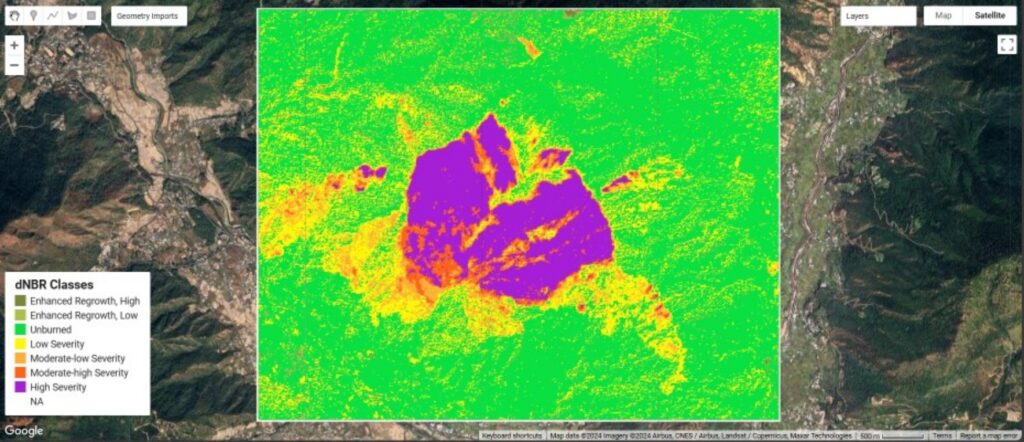
️ Interactive Burn Severity App – View an example mapping the 2018 Thsendona Fire with satellite imagery
️ Google Earth Engine Lesson Plan – Step-by-step coding activity PDF to build the map above
Full Article (Taylor & Francis) – Explore the full lesson plan and relevant background information.
This work is meant to be shared. The lesson plan is adaptable, cost-effective, and rooted in real-world relevance. We’d love to connect with fellow educators working at the intersection of technology, place, and student-led inquiry. Please reach out if you’re interested in collaborating or adapting this model to your specific context.
#PlaceBasedEducation #RemoteSensing #GeospatialLearning #GoogleEarthEngine #WildfireEducation